Dorchester County, MD
Allie Goldstein
The tall pine stands at the edge of the marsh look permanent to the untrained eye, but when we step off the pavement and onto the forest floor, the ground sways like a mattress. We’re standing on what Erik Meyers calls terra infirma.
“This is all history,” he says. “This is all going to be gone.”

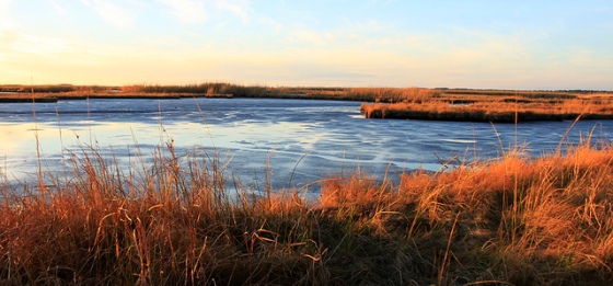
Sunset over the marsh at Blackwater National Wildlife Refuge in Dorchester County, which is highly vulnerable to sea level rise. | Photo: (c) Whitney Flanagan, The Conservation Fund
Meyers is the Vice President of The Conservation Fund (TCF), a non-profit that has financed 100,000 acres worth of conservation in Dorchester County, Maryland, including nearly 8,000 acres of restoration in Blackwater National Wildlife Refuge, where we’re standing. It’s a stunningly beautiful and historically important place: Harriet Tubman grew up in the area and later led escaped slaves through the tall marsh grasses on the Underground Railroad. Today, the Reserve supports some of the most important habitat on the Atlantic Flyway, the major bird migration corridor on the East Coast. About two-thirds of this land is threatened by sea level rise.
From marsh to open sea
A time series of maps for Blackwater stretching from the present to 2100 tells a story of loss: the maps fade from green to blue like a mood ring as sea level rises half a meter, then a meter, until the marsh converts to open water.

SLAMM (Sea Level Affecting Marshes Model) simulations show dramatic marsh loss in Blackwater National Wildlife Refuge (the cross-hatched area) and its surroundings by the end of the century. Red areas indicate (diminishing) critical bird habitat if people do not intervene.

Matt Whitbeck, a wildlife biologist at Blackwater, describes a major ecological transition driven by sea level rise. | Photo: (c) Whitney Flanagan, The Conservation Fund
Due to its particular vulnerability to sea level rise, 380 acres of Maryland’s shoreline erodes into the ocean every year. Average temperatures have increased 2° Fahrenheit in the Mid-Atlantic since 1970, with an additional 2-4° F rise projected by mid-century. With these hotter temperatures, the Maryland Commission on Climate Change expects 0.6 to 1.3 feet of sea level rise by 2050—and up to 3.4 feet by 2100. Because Dorchester County is low-lying, the consequences of several feet of sea level rise will be particularly dramatic here.

Observation deck or fishing pier? Resource managers plan to intervene in the process of marsh loss. | Photo: (c) Whitney Flanagan, The Conservation Fund
Standing on a planked observation deck overlooking a gorgeous slice of marsh, Matt Whitbeck, the Supervisory Wildlife Biologist for Blackwater, describes what would happen if people did nothing to stop marsh loss at the Refuge: “This here platform would become a fishing pier.”
But this is not an inevitable fate, and TCF is determined to write a different ending to Blackwater’s story. Along with Audubon Maryland-DC and the U.S. Fish and Wildlife Service, they are implementing strategies to help the tidal marshes keep their heads above water into the next century. Suzanne Baird, the Refuge Manager at Blackwater, secured grant funding from the Maryland-based Town Creek Foundation for TCF and Audubon to write Blackwater’s adaptation plan together.
The disappearing marsh mystery
At first, the main cause of marsh loss in Blackwater actually wasn’t obvious. Instead of encroaching on the Reserve from its edges, sea level rise is eating away at Blackwater from the inside out as tidal waters flow through Blackwater Lake, in the middle of the marsh. Researchers and resource managers spent years trying to figure out the origin of the “5,000-acre hole” that formed over the last century.

It wasn’t always obvious that sea level rise was the major driver of Blackwater’s marshes slowly converting to open water. | Photo: (c) Whitney Flanagan, The Conservation Fund
They considered groundwater withdrawal, which could be causing the marsh to sink. But water extraction has slowed after Dorchester County’s canning operation shut down after World War II. They considered the controlled burns on the Reserve, which could potentially be affecting marsh growth rates. But US Geological Survey data shows that marshes exposed to fire are not sinking any faster than fire-free ones. They considered nutria, an invasive mammal that relentlessly eats away at marsh grass. But the South American species is rarely seen after a successful eradication program at the turn of the millennium. And they considered the land subsidence that has been occurring since the glaciers retreated from this landscape. But it is very slight.
So, though many different factors may play some role, process of elimination pointed to sea level rise as the major driver of marsh loss. An ongoing study that uses Surface Elevation Tables to measure sediment levels relative to sea level at 77 points around Blackwater confirms the hunch.
“To boil it all down to its essence, the marsh isn’t building elevation fast enough to keep pace with the local rates of sea level rise,” Whitbeck explained.
Setting sights upslope
The authors of Blackwater’s adaptation plan realized that they had two options: They could try to beat the sea by building marsh elevation faster than the rate of sea level rise. Or they could facilitate the transition of marsh upslope.

Blackwater’s Adaptation Strategy identifies a few areas (inside the pink polygons) where marsh restoration may be worth it. Elsewhere, marsh migration is the most promising strategy.
The former is possible, but difficult. A feasibility study by the Maryland Port Authority on restoring Blackwater Lake using dredged material from Baltimore Harbor estimated that building back the submerged marsh would cost between $270,000 and $726,000 per acre—at 3,700 acres, the total restoration is priced between $10 and $27 billion. Given these astronomical costs, the adaptation plan calls for using dredged material from navigation channels only to do thin-layering of sediment on slowly eroding, critical marsh—not to recreate marsh that has already converted to open water.
Overall, facilitating marsh migration upslope is much more feasible than fighting what is likely a losing battle against sea level rise. As TCF and the Audubon Society point out, Blackwater is uniquely positioned to give its marshes space to move.
“Because of the rural nature of this part of the Chesapeake Bay, because of the low population density, because of the broad, flat landscape, there’s every reason to believe these marshes will be able to migrate and we’ll continue to be able to have some of the most expansive wetlands in the Chesapeake Bay,” said Whitbeck.
A new management paradigm

180,000 visitors come to Blackwater every year, many of them birdwatchers. Key species include the saltmarsh sparrow, the clapper rail, the American black duck, and the willet. The Refuge also supports 600 jobs and provides $6 million in local tax revenue. | Photo: (c) Whitney Flanagan, The Conservation Fund
The idea of actively managing the transition from forest to marsh is a somewhat new concept for resource managers, who are typically less inclined to purposefully alter the ecosystem. But unprecedented rates of sea level rise call for a new paradigm, so Whitbeck and Dave Curson, the Director of Bird Conservation at Audubon Maryland-DC, coined what they think is a new term: Managed Marsh Transition. Sea level rise guarantees that, in 100 years, the critical bird habitat won’t be in the same place as it is today. The trick is that habitat cannot be lost and then reestablished upslope a decade later. The birds, some species of which are found nowhere else, need a place to nest every year in order to maintain minimum populations.
“Where are these jaw-dropping, high-value, gorgeous marshes going to be in 2050 or 2100?” Whitbeck asked. “And how can we get from here to there without having a break in the species continuity?”

Phragmites, an invasive grass species, is the “fly in the ointment” to Blackwater’s adaptation efforts. As salt water intrudes into the forest, “ghost trees” like the one pictured provide posts for predatory eagles. | Photo: (c) Whitney Flanagan
Marsh migration is indeed occurring on its own—3,000 acres of upland pine forest have converted to marsh since the 1940s—but not in the way that resource managers would prefer. Without human intervention, an invasive grass, Phragmites, usually becomes the dominant species in the transition zone between forest and emergent marsh. Though Phragmites does provide some storm protection for Chesapeake Bay communities, many critical bird species avoid the monoculture since it is too tall and thick to support their habitat.
The cornerstone of Managed Marsh Transition in Blackwater is therefore Phragmites control. The adaptation plan calls for eliminating new Phragmites stands with chemical herbicides to give native cordgrass a fighting chance. Another, new idea is to salt the ground in transition zones in order to give the more salt-tolerant native cordgrass an edge. And a pilot project funded by the Wildlife Conservation Society’s Climate Adaptation Fund will test whether proactively cutting down doomed “ghost trees”, therefore eliminating perches for predators like eagles, will encourage other critical bird species to move in.

As Blackwater’s marsh migrates to higher ground, the species composition in transition zones like this, where marsh meets forest, are key. | Photo: (c) Whitney Flanagan
Leave room for the sea
The success of Blackwater’s adaptation plan depends not only on the ecological viability of the marsh, but perhaps equally on the economic and political feasibility of converting significant swathes of land in the right way. Within the two primary marsh migration corridors identified in the adaptation plan—Nanticoke River and Coursey’s Creek—5,500 acres are currently used for agriculture, 60% of which are protected through conservation easements.
Sudeep Mathew, an Agriculture Extension Educator for Dorchester County, says that though farmers and environmental groups have in the past clashed over regulations around the Chesapeake Bay, they do agree on one thing: that farming is preferable to development. Over half of Dorchester County’s land is in the 100-year floodplain, and given the sea level rise projections, it simply doesn’t make sense to invest in building in some places.
Anne Roane, the city planner for Cambridge, the seat of Dorchester County, is pushing the region to develop in a way that allows the sea some breathing room. “We want to do infield development and not build in these outlying agricultural areas that are vulnerable,” she said.
The switchgrass lightbulb
Eventually, increasingly salty soils and storm surges will make farming around some areas of Blackwater impossible. But that transition can be carefully managed in order to keep farmers on the landscape as long as possible.

Erik Meyers, Vice President of The Conservation Fund, believes that there is hope for Maryland’s iconic tidal marshes. | Photo: (c) Whitney Flanagan, The Conservation Fund
When the idea of growing salt-tolerant switchgrass, which is already used by Delaware’s poultry industry as bedding in the chicken coops (an alternative to wood shavings), came up, Meyers said that a lightbulb went off: “What a great win-win for farmers to start utilizing switchgrass plots. It could service the poultry industry here, and it would keep farmers on their land for a much longer period of time.”
“The water is coming anyway,” Curson explained. “In the meantime, [farmers] could make some money through sales of switchgrass.”

Most of the land around Blackwater National Wildlife Refuge is used for agriculture or timber. | Photo: (c) Whitney Flanagan, The Conservation Fund
The crop could be grown in the period after the ground is too salty for other crops and before the time comes for salt marsh to take over. TCF is currently looking for a field that’s suitable for a switchgrass pilot project. The key will be to set up the market infrastructure with the poultry industry that makes the crop economically viable.
Effectively communicating the idea to farmers will also be essential. Farmers in the area are “very aware” of the problem of sea level rise, Mathew said, but they “probably don’t know the intensity.” A map that shows over half of the land within Route 50 submerged by 2100 might be a bit demoralizing.
“It’s a shocking transformation of the landscape,” Meyers said. “We don’t want people to throw up their hands and say ‘why bother?’”
Dare we hope?
Whitbeck recalls his time in school—not that long ago—when resource managers were taught that the ‘gold standard’ was to restore a landscape to pre-colonial condition.
“What this piece of land or water or marsh looked like when Columbus bumped into North America—that was the standard,” he said.

Suzanne Baird, the Refuge Manager at Blackwater. | Photo: (c) Whitney Flanagan, The Conservation Fund
The rapid rate of sea level rise along Maryland’s coast leaves little hope for ecologists to recreate the Blackwater of 1933, when the Refuge was founded. There is hope, however, to maintain the ecological value of the marsh somewhere on the landscape. Over the last decade, resource managers have put more emphasis on conserving ecosystem services rather than specific places. In other words, Maryland’s marshes may be located on completely different acres in 100 years, and that’s okay, as long as they continue to provide critical habitat for birds and other creatures and storm surge protection for Chesapeake Bay residents.
The members of the partnership are creative, resourceful, collaborative—all adjectives that help to make them adaptive. But perhaps most importantly, they’re committed to action, even in the face of uncertainty.
“What’s the worst that could happen?” Meyers asked. “You protect all this great open space and it doesn’t convert to marsh immediately. The science isn’t perfect and the map isn’t perfect, but we have enough information to move forward.”

Most photos in this piece are thanks to Whitney Flanagan, Design Manager at The Conservation Fund. Here she is in action.

Reblogged this on U.S. Fish and Wildlife Service Northeast Region and commented:
Climate blogger Allie Goldstein spent some time with our folks at Blackwater National Wildlife Refuge in Dorchester County, Maryland, an area highly vulnerable to sea-level rise. Read how we and are partners are creatively responding to the migrating line between the ocean and the marsh.