
Portsmouth, NH
Kirsten Howard
With the road trip part of the Adaptation Stories project now complete, I’m walking along narrow brick lined streets through the Historic District of my new hometown: Portsmouth, New Hampshire. This quaint Atlantic Seacoast community was the third settled U.S. city, so the homes in the South End neighborhood are historic gems. Some played host to George Washington in the 1700s, while others housed factory workers in a more industrial era.

The Portsmouth Flood Risk Walking Tour marches along the streets of historic Portsmouth, NH
But the guided walking tour that I and 22 other Portsmouth residents are on isn’t only to appreciate the neighborhood. Rather, we’re walking to learn about how we, together with the city’s Coastal Resilience Initiative (CRI), can ensure these homes that are a key part of Portsmouth’s culturally rich and tourism-based economy don’t float away–or sink–as sea level rise and storm surges increase with climate change.
The CRI is a project through which city staff and academic researchers assessed flood risks in the city. The CRI, funded along with four other coastal New England communities, by the Gulf of Maine Council and the National Oceanic and Atmospheric Administration (NOAA), lays out several sea level rise and storm scenarios for Portsmouth.
“This is an important environmental planning issue for the city—we need to know where our vulnerabilities really are,” says Peter Britz, Portsmouth’s environmental planner and the organizer of the walking tour.

This figure from the Portsmouth Coastal Resilience Initiative shows today’s mean sea level (MSL), today’s mean high tide (MHHW), and the storm surge if a 100-year coastal storm hit today. Over time, sea levels will rise, and storm surge would reach even higher. If humans continue emitting greenhouse gases at high levels, a regular high tide could reach close to today’s storm surge–that means close to the top of the first story window.
When, where, and how much?
Depending on greenhouse gas emissions, sea level will rise in Portsmouth between 1 and 1.7 feet as soon as 2050. By the end of the century, average sea levels are projected to be between 2.5 and 6.3 feet higher than today—a person standing at today’s high tide mark in the South End might, in 2100, be completely submerged. This represents a sharp increase in the rate of sea level rise due to what scientists call ‘thermal expansion’ (as the seas get warmer, water takes up more space) and melting glaciers worldwide. For comparison, the Portsmouth sea level has risen about 0.7 inches per decade since local tide gauges began recording sea level in 1926. Add to the predicted sea level rise a story-high storm surge from a coastal storm similar to Hurricane Sandy, the likes of which are expected to increase in frequency with climate change, and the fury of the tides looks pretty unforgiving.
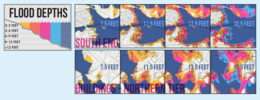
The Portsmouth CRI developed scenario maps to show what parts of Portsmouth are at risk if sea levels and storm surge cause the water to reach predicted heights.
The CRI didn’t just stop at predicting the amount of future flooding expected–Britz and his team also created maps that identify where the flooding will occur. And this is what Britz and CRI project team member Dr. Dave Burdick of the University of New Hampshire are demonstrating with a walk. They lead us into Prescott Park, a 10-

Dr. Dave Burdick sets up the laser level in Prescott Park. These tools help us figure out how high future flooding might reach.
acre park located along the Piscataqua River in the South End that serves as an important cultural center for the community. Referring to their flood maps, Britz and Burdick split the walkers into two teams, give us each laser levels to measure elevations, and leave us to figure out where the water would reach in the park if a 100-year coastal storm hit today and in 2100. A beep from the laser level means we’re standing at the highest point where water will get our toes wet.
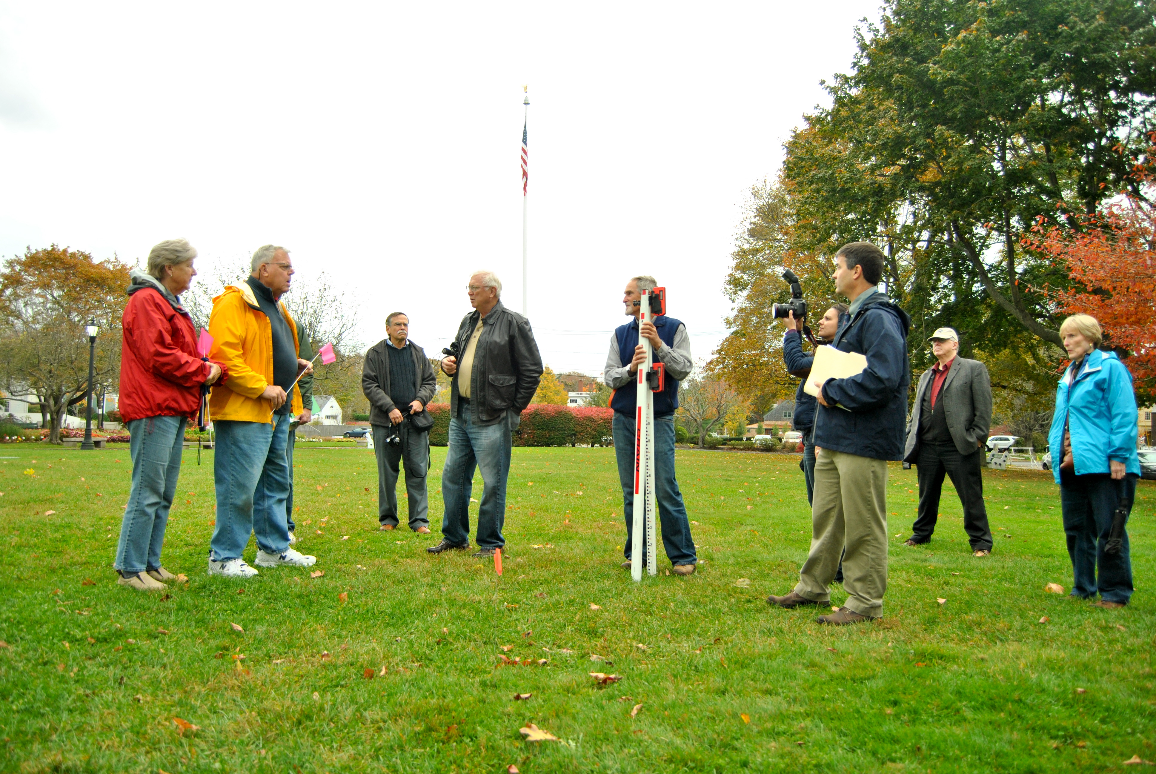
Peter Britz and one team of walkers explore the floodline with their laser level. Prescott Park is an important place in the Portsmouth community.
In the middle of the lawn where the widely-attended Prescott Park Arts Festival concerts are held each summer, the laser beeps. We look around us and down toward the cars and buildings that water would submerge in today’s storm. The other team of walkers, armed with a laser that indicates projected storm surge in 2100, is even further up toward the street, at 18 feet of elevation. Judging by our positions, there is no doubt that if a Hurricane Sandy equivalent hit today or in 86 years, it would seriously impact Portsmouth residents and much of that historic Portsmouth charm.
Walking in search of solutions

The Mechanic Street seawall was built to blend into the historic aesthetic of the South End community. It can be added to over time.
We file out of the park and down a few more blocks to see more at-risk homes and some of the structures in place to protect them. In order to preserve the historic nature of the South End houses, building regulations are fairly restrictive, so the common flood protection strategy to raise homes on stilts is not a viable solution here. Instead, some of the homes are protected by stone seawalls. At Mechanic Street, we inspect a seawall that was rebuilt in 2011. The city’s Conservation Commission made sure the wall could be added to if rising seas begin to threaten the homes behind it. The wall also contains a stormwater drainage pipe with a one-way valve that allows rainwater to flow from the streets into the harbor, but closes up to keep water from pushing its way back up the pipe in a flood.

The seawall stormwater drain with a one-way valve protects streets from flooding.
“A unique thing about the seawall project is that Portsmouth didn’t get dedicated grant money to design it for sea level rise—it used existing Capital Improvement Funds,” Britz

Britz explains the kinds of adaptation actions that Portsmouth is considering to protect communities.
explains. “The fact that the Conservation Commission asked whether the wall could be elevated further shows they’re starting to think about incorporating this information directly into planning.”
Britz is hoping to integrate the CRI results into the upcoming redraft of Portsmouth’s Master Plan and infrastructure improvement projects over time. One of the first such projects the city will likely consider next year is to elevate a sewer pump station near the new seawall that is currently vulnerable in large storm surges.
Adapting together
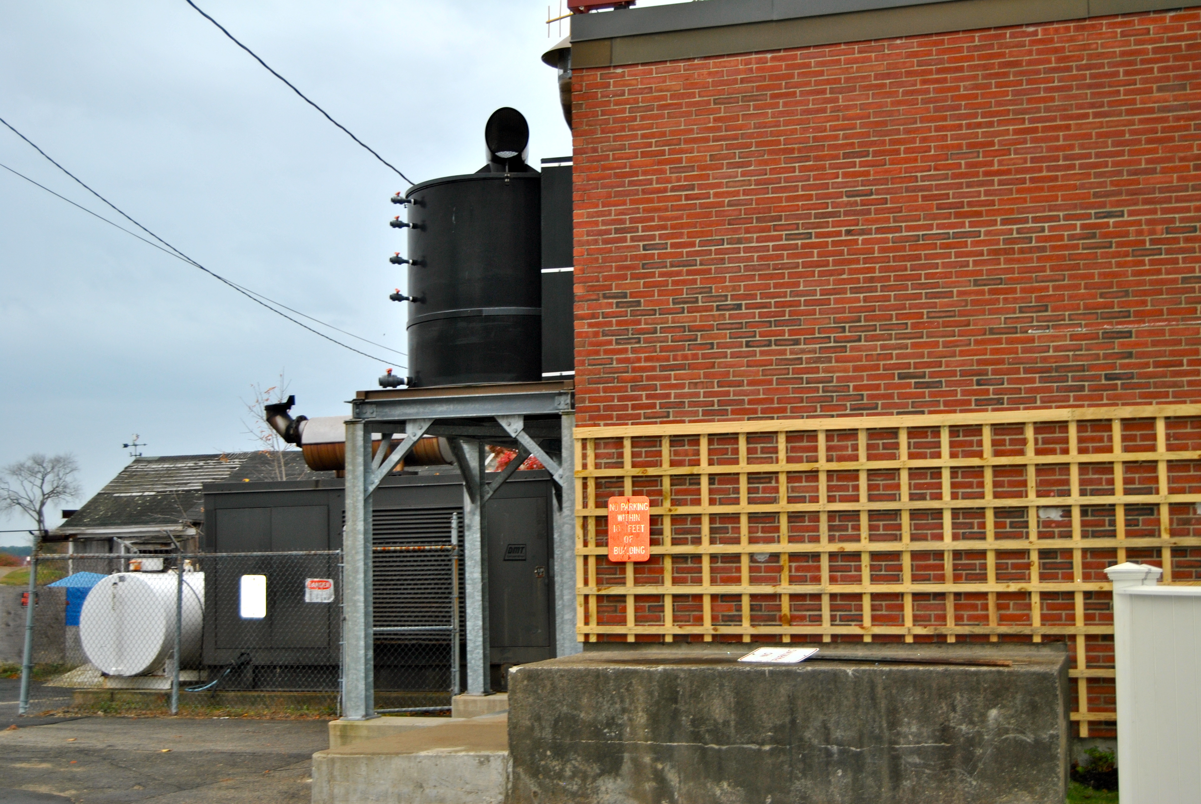
This pump station might need to be protected from floods in the future.
As we meander through tightly-packed homes in the South End, it’s clear that some members of the group are disconcerted by the sea level rise predictions for their beloved neighborhood. At the same time, the walkers seem relieved to know that city staff are starting to thinking about preparing, and in a few cases have taken action. For some, like 18-year South End resident Judy Sabin, it’s a welcome shift beyond the tired rhetoric she has often heard refuting climate science—rhetoric that can hinder preparation.
“At some point you just have to believe and make a plan,” she tells me as we walk back to the local playhouse for apple cider and more lively discussion.
Over cider and cookies, Britz and other walking tour participants shared more plans for projects to build resilience on the Seacoast. New Hampshire’s coastline itself is hypothetically walkable—at 18 miles, it’s shorter than a marathon course. Add the tidally-influence estuarine lands and the number jumps up to 238 miles that will likely be affected by sea level rise and coastal flooding, but even so, New Hampshire has a small area to consider compared to many coastal states. This might be a blessing when it comes to protecting the seven coastal towns and additional estuarine communities from the expected impacts of climate change. The vibrant communities that lie along the New Hampshire marshes and beaches can collaborate and share lessons with relative ease. With that in mind, Sherry Godlewski of the New Hampshire Department of Environmental Services and Steve Miller of the Great Bay National Estuarine Research Reserve (GBNERR) helped create and now co-chair the Coastal Adaptation Workgroup in 2010.
“We felt we needed to work together to help communities prepare for the changes we were seeing in our climate. We had seen a number of really extreme events and we knew we were likely to see more,” said Godlewski.

This tidal pond drains at low tide and fills at high tide, sometimes to very high levels.
The group, affectionately nicknamed CAW, is composed of more than 20 local and regional organizations and meets monthly to organize public workshops, discuss developments like the upcoming update to the Federal Emergency Management Agency flood insurance maps, and collaborate on new community adaptation projects. CAW organizations have secured over $2.5 million in resilience-based grant funding since the group’s inception. One project, led by the Rockingham Planning Commission, provides high resolution sea level rise and flood risk maps, like the ones created for Portsmouth, for the other six coastal communities.
“CAW’s collaborative structure is what makes us so successful. We each bring personal and professional skills to our work. During our workshops, we really listen to what communities ask for and we put our heads together to figure out the best way to deliver that,” Godlewski said.
Preparing isn’t all about the hard stuff
One such project that CAW members are involved with looks at more natural solutions to flood risk. While some highly developed and regulated areas like the South End have limited solutions to choose from, hardened shoreline structures like seawalls and raised buildings aren’t the only answers in other areas surrounding Portsmouth. Sometimes “hard” infrastructure can do more harm than good if it destroys habitat or simply deflects storm surge elsewhere, and it can be costly to maintain. Where possible, adaptation experts are increasingly pointing to “softer” solutions, that use natural infrastructure like salt marshes, sand dunes and oyster beds to break waves in a storm. The Great Bay Estuary, which flows into the sea at Portsmouth Harbor, is a good candidate for this kind of “soft” resilience—it’s home to diverse wildlife, including salt marshes that filter pollution and provide critical fish and wildlife habitat and flood protection.

Salt marsh stretches out to Great Bay–a valuable part of the coastal New Hampshire ecosystem
Another benefit of “soft” over “hard” coastal infrastructure is that, in a future with much higher sea levels, marshes will need to migrate back onto land to maintain the right balance of fresh and saltwater flushing they need to survive. In many locations where buildings and seawalls have been erected just behind the marshes, marsh grasses will be caught between death by drowning and a hard place. To address this problem, GBNERR and several partners are using a mapping program called SLAMM (Sea Level Affecting Marsh Migration) to model marshes along the New Hampshire seacoast and identify areas where they still have the opportunity to migrate.
“Knowing where marshes can migrate will help inform land acquisition and restoration investments and priorities,” said Cory Riley, the manager of GBNERR.

These boots are made for walking–or wading. The highest tides of the year already cause flooding in some Portsmouth parking lots–will I need hip waders in 2050?

Thanks for information that has an impact throughout the community… Bob